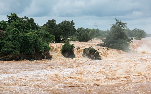
Characterized by heavy flooding lasting from June to September – roughly one-third of the year – India’s summer monsoon system is the world’s most prominent. This devastating weather event affects the lives of over one-sixth of the world’s population; in 2018 in Kerala, for example, more than 400 people died and millions more were displaced in a single series of floods.
A new study, led by Dr. Shira Raveh-Rubin of Weizmann’s Earth and Planetary Sciences Department and postdoctoral fellow Dr. Deepika Rai, suggests that monitoring dry air may be the key to improving flood warnings.
The monsoon rains that pelt the Indian subcontinent from July to September are multifaceted phenomena complicated by a combination of numerous factors. One critical factor identified by Dr. Raveh-Rubin and her research team is a subtype of airstream known as a dry intrusion.
Comprised of air that is not only dry but also cold – especially relative to the steamy, wet air of a monsoon downpour – dry intrusions that cross the equator from the south to the north are only known to occur around the Indian subcontinent.
As part of their research, Dr. Raveh-Rubin and Dr. Rai looked at the data of dry intrusions in this part of the world and found that 137 instances had been recorded between 1979 and 2018. In comparing these events with precipitation records from around the same time, they also found that they were not followed by dry weather, but rather, by an increase in rainfall – of 17 percent, on average, and in some cases, of over 100 percent.
So, how exactly does dry air produce more rain? Acting as a sponge, the dry air of the intrusions absorbs water from the Indian Ocean and transports it northward toward India’s west coast on the Arabian Sea; the larger the moisture gap between the ocean’s surface and the intrusions, the more water the intrusions absorb.
Dr. Raveh-Rubin believes that employing dry intrusion monitoring to predict peaks in heavy rainfall might translate into extending flood warnings in places like India and Bangladesh from a day or two to about a week. This improvement would enable the millions of people who live on flood plains to properly prepare for such events and, if needed, evacuate, potentially saving hundreds – if not thousands – of lives.
Dr. Raveh-Rubin and her group intend to continue studying the effects of dry intrusions on the Asian monsoons while searching for places in the world in which they have similar effects. They’re hopeful their research will help them understand how and why these patterns form and improve our ability to predict severe flooding – while leading to improved outcomes for the people whose lives are impacted most.

